| What is NEXT |

ABOUT THE PROJECT

The project NEXT (New Exploration Technologies) will highlight the possibilities of exploring for raw materials in Europe in the most sustainable and socially acceptable way leading to an extension of the knowledge of existing deposits in Europe.

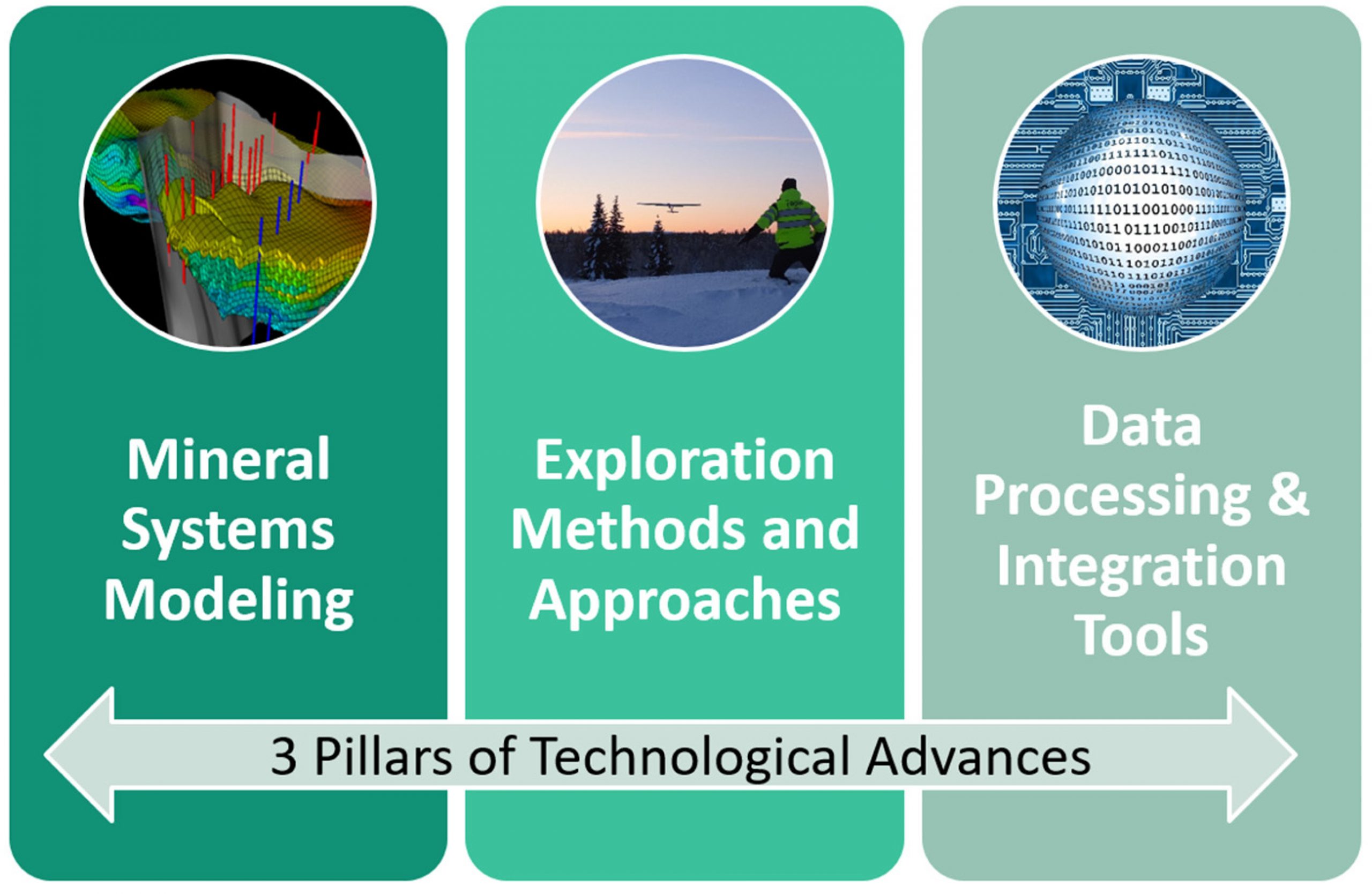
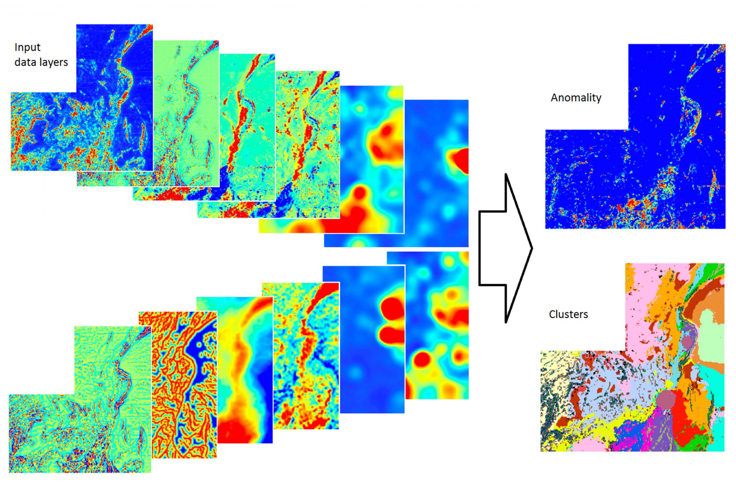
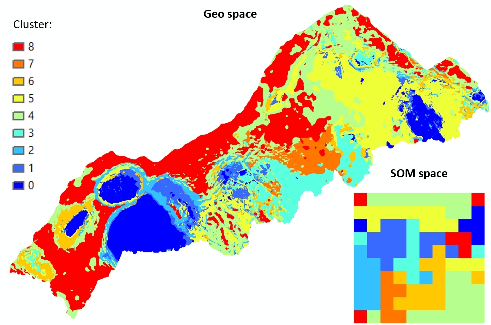
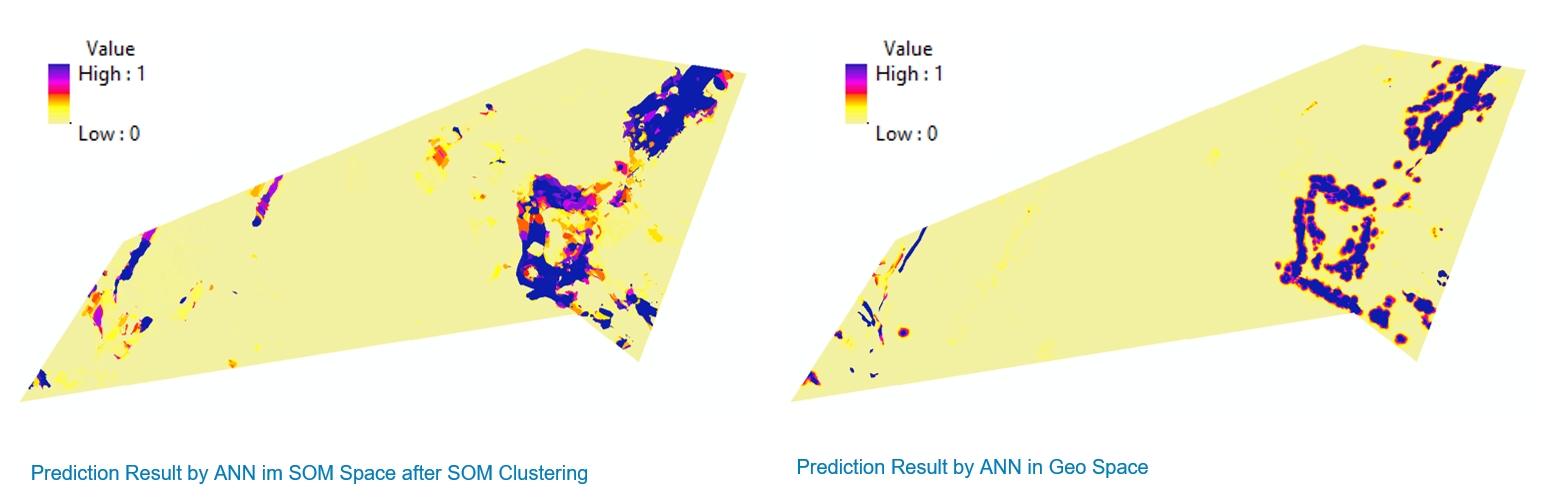
NEXT will enhance our understanding of the mineral systems and develop new more sensitive exploration techniques. By integrating industry, academia and research institutes with expertise and excellence in exploration and 3D modelling, it is our ambition in NEXT to develop new cost‐efficient tools that are specifically aimed at increasing the competitiveness of the European exploration industry.

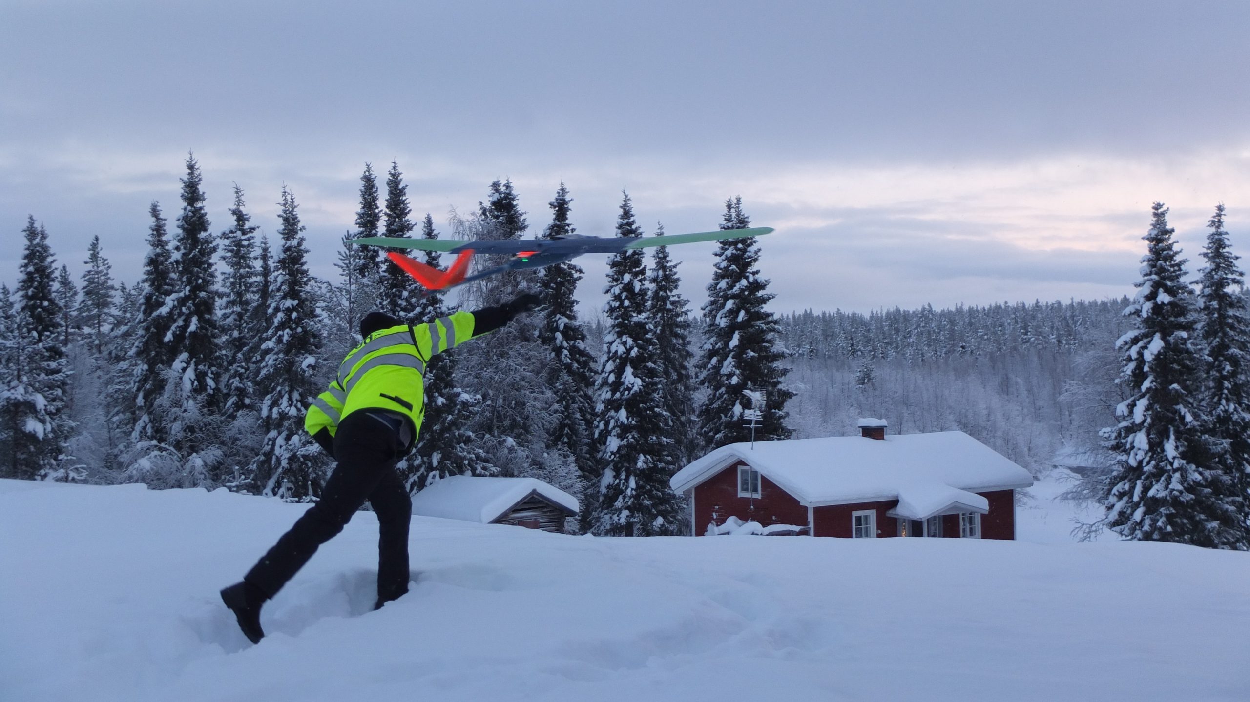
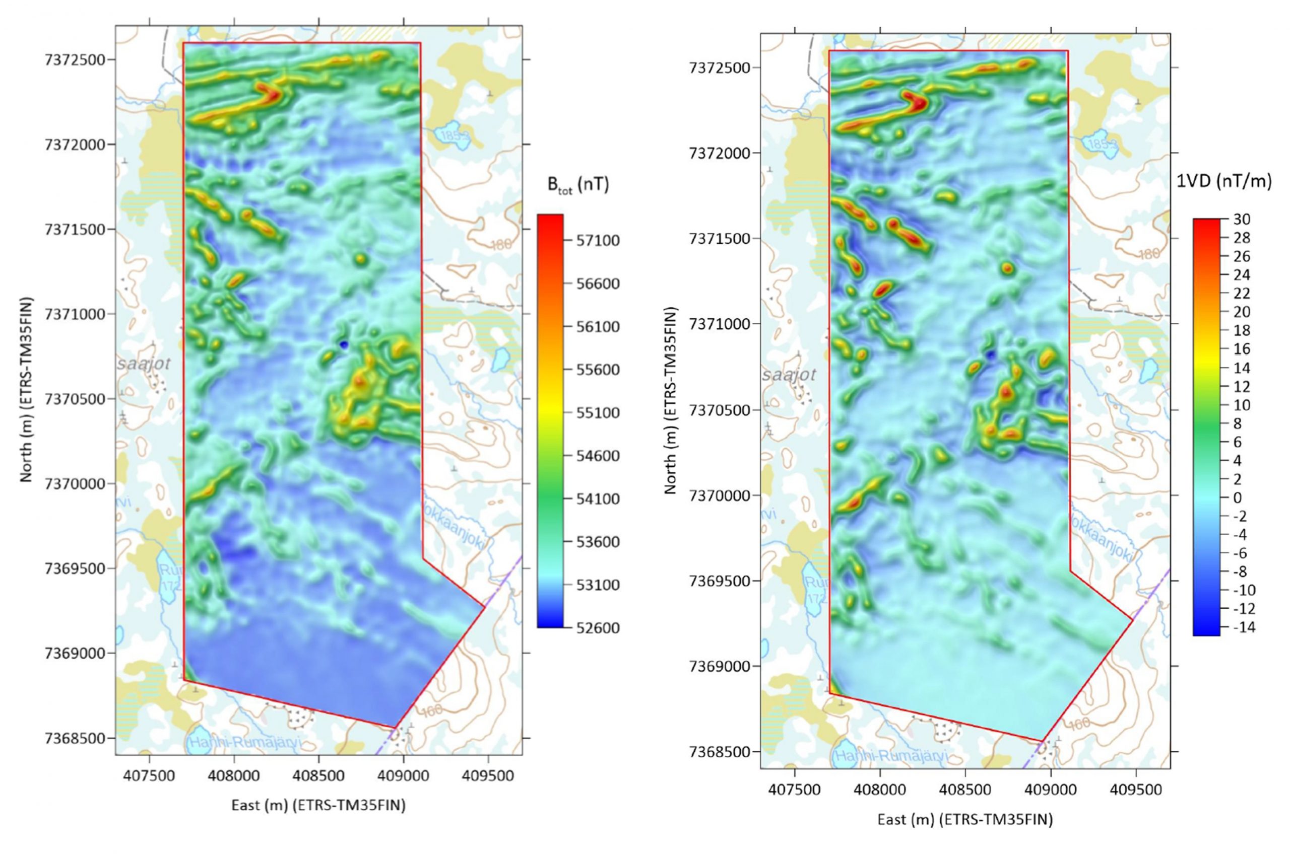
NEXT will create a totally new concept of unmanned aerial vehicles (UAV) technology for geophysical surveying combined with the well‐established but constantly emerging portable geochemical exploration tools (XRF, LIBS, Raman) and remote sensing technologies.

NEXT is built on three pillars of technological advance

| New Exploration Methods |

MINERAL SYSTEM MODELING

The aim of this work package is to develop conceptual mineral system and exploration models for selected main and/or poorly known ore districts in Europe, including major Cu-Au and Au-Co mineralization in the Lapland region, the volcanic-hosted massive sulphides of the Iberian Pyrite Belt, W-Sn mineralization in Western Iberia and IOCG-like projects in SW-Spain. The aim of these multidisciplinary studies including basic geology, structural geology, geochemistry and geophysics is to develop 3D models that help to predict the location of ore deposits and a transition from brownfield to greenfield exploration in the most important field camps in Europe.

Field work in the Pyrite Belt: Geologists develop geological maps, take samples, make structural measurements and collect samples. This work is the basis for the successful interpretation of all the geochemical and geophysical techniques used in the NEXT project
Logging of drillcore complements field work and helps to understand the 3D distribution of the orebodies and its geological, mechanical and geophysical properties.
Massive ore at the Alconchel project – this poorly known IOCG-like mineralization in SW Iberia has a great potential for copper. The combination of a suitable trap such as large bodies of stratiform iron oxides and the presence of feeder zones channelizing Cu-rich fluids promote the existence of high-grade orebodies
Structural map of the Painirova-area in the easternmost part of the Kiruna mining district. The map highlights the crustal architecture and structural controls on iron deposits and overprinting copper-gold deposits. The structures are deforming and re-mobilizing the massive magnetite iron deposits and provide fluid conduits for the later copper-gold-bearing hydrothermal fluids

The second aim of this work package is to develop a systematic approach for the definition of pathfinders and vectors to ore for the aforementioned ore deposit styles using some selected deposits such as Rompas-Rajapalot (Au-Co, Finland), Aguas Teñidas-Elvira (Cu-Zn-Ag, Spain) or San Finx (Sn-W, Spain). The aim of this study is that the combination of lithogeochemical, mineralogical and isotopic studies should predict the deep geological volumes with the highest chances of hosting an orebody by combination of the definition of the most favourable lithologies and the existing ore traps expressed by the presence of subtle halos of hydrothermal alteration.

Through the detailed characterization of the whole rock geochemistry of the host sequence to the Aguas Teñidas ore deposit in background and hydrothermally altered zones it has been possible to identify indicator elements (Zn, Pb, Cu, As, Cd, Sb, Tl) whose contents increase towards the deposit (vectors to ore), and to establish threshold values which discriminate between zones within and away from the influence of mineralizing fluids
Block model of the Raja prospect based on work of Jackson van den Hove (PGN Geoscience) for Mawson Resources

DATA PROCESSING AND INTEGRATION TOOLS

The existing data integration and clustering algorithm of Self‐Organizing Maps (SOM) has been successfully redeveloped as open‐source (OS) “nextSOMcore”. It has now been integrated by GTK into a new open-source GIS software package, called “GisSOM”. In addition, it has been integrated into “Esri ArcGIS” as free available Toolbox and as new extension into the commercial software “advangeo® Prediction” by Beak. The SOM approach has been tested with existing data from the Erzgebirge site and will now be applied to the available and newly acquired data from the target areas in Rajapalot and Elvira.

Example of data integration using SOM: Multiple input data layers from geophysics and geochemistry are combined to produce maps showing either the level of anomality or the areas with similar properties (so‐called SOM clusters).
SOM cluster map of the Erzgebirge area based on input data from stream sediment geochemistry, aeromagnetics, gravimetry and aero gamma spectrometry
Comparison of potential maps for Sn skarns in the western Erzgebirge – Left: Compiled by application of ANN in SOM space after SOM clustering and transformation back into geo space, Right: Compiled by application of ANN in geo space

UAV ELECTROMAGNETIC TECHNOLOGY

The first prototype of the new electro‐magnetic (EM) system has been built in 2018 by Radai and an improved system tested in autumn 2019. The prototype system consists of EM transmitter and receiver units which can be carried by drones or humans.

Field test of EM drone prototype system

For the EM system also new interpretation tools have been implemented into new software tools by Radai.

Magnetic total field (with sun shading) of the Palokkaanlampi survey area computed at the constant height of 10 m using ELM of low, mid and high‐altitude data jointly (left). First vertical derivate of magnetic total field computed at the constant height of 35 m (right).

MULTI‐SOURCE SURFACE GEOCHEMICAL AND SPECTRAL INVESTIGATIONS

This year two successful data collection campaigns at the Raja prospect in Ylitornio, Finland, were completed. In March 2019, a field crew from GTK collected snow samples in the study area of 2.5 km across. In summer, the same field sites were revisited for performing a plant and soil survey campaign. Top organic and mineral soil, foliage and tree bark, as well as transpired fluids from spruce foliage were sampled to be analysed for elemental and hydrocarbon concentration. Altogether 98 sites were visited resulting in more than 1,000 soil and plant samples and soil measurements. At the test sites in Spain, hyperspectral measurements in the field and on 7 km of drill core have been completed by HZDR/HIF.

NEXT field crew during the summer field sampling campaign in Finland

| Improving the Relations between Mining Industry and Broader Society |

SOCIAL LICENSE TO EXPLORE ANDOPERATE (SLO)

In the work package on SLO, key factors that influence the effectiveness of social licensing during the exploration phase are being identified. Now a policy brief on the importance and effectiveness of practices used to assess social impacts and interact with the local communities will be published.

NEXT public info day at local community in Finland

| Figures |

Call: H2020‐SC5‐13C‐2016‐2017 – New solutions for sustainable production of raw materials

Duration: 01.05.2018 ‐ 30.04.2021

Total budget: 6.9 MIO. €

Consortium: 16 partners from research institutes, academia, service providers and industry from 6 EU countries – Finland, Spain, Sweden, France, Germany and Malta

Coordinator: GTK (FINLAND)