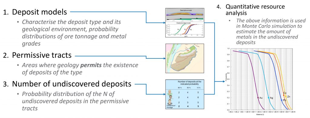
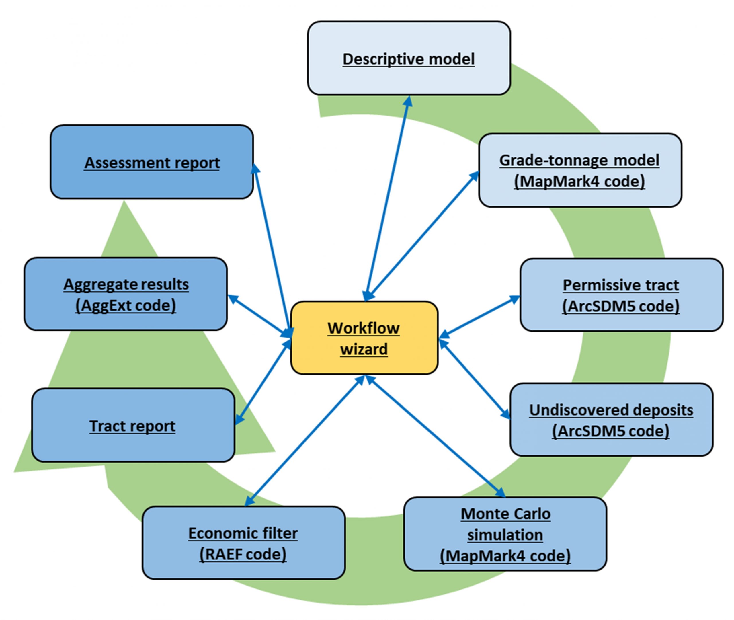
Map Logo

| What is MAP |

The project will produce an enhanced and upgraded method and software for the quantitative assessment of undiscovered mineral resources, by integrating mineral prospectivity modelling and the three-part method. The testing phase of the software will produce valuable information on undiscovered resources in the Nordic countries and Germany, and on the Arctic deep ocean floor. The MAP software will increase the productivity of its users and create new business possibilities for service providers.

| Background |

Reliable information concerning the locations and amounts of undiscovered mineral resources is important for several purposes. Exploration and mining companies require such information to support investment decisions, and political and administrative organisations need it to support decisions concerned with land-use planning. Research institutions use the information to widen and deepen the knowledge on raw material deposits and to be able to deliver advice to the society, industry and administrative and political entities.

US Geological Survey (USGS) has developed the so-called three-part quantitative assessment method, which is used to provide estimates of the location and amount of undiscovered mineral resources. The method has been in use since the mid-1970s, and for the last decade, Geological Survey of Finland (GTK) and USGS have used it to assess selected metallic commodities on global and national scales.

Although the three-part method framework is considered sound, there are features missing from the present workflow and software used, which would increase the value and usability of the assessment results. These include further automation of the process of delineating areas to be assessed, classification of the assessment areas based on their mineral potential, estimation of the proportion of the undiscovered resource that could be economically recoverable, and smooth workflow throughout the whole assessment process. Training and education are needed to increase the awareness and understanding concerning the assessment method and products. The MAP project aims to address these issues.

| Objectives |

The MAP project will upgrade and enhance the assessment method, workflow and software. The new assessment process will be based on the integration of mineral prospectivity modelling (MPM) tools into the three-part method. The new software will enable the use of MPM in the delineation of the assessment areas (‘permissive tracts’), in the classification of the permissive tracts based on their mineral potential, and in the estimation of the number of undiscovered deposits within the permissive tracts. Tools for reporting the results will also be included in the software. The MAP software will ensure smooth workflow and transfer of data by guiding the user through the whole assessment process. The modular structure of the software will enable the easy modification and adding of new tools.

Overview of components of MAP Wizard software

The developed method and software will be thoroughly tested with several mineral deposit types (volcanogenic massive sulphides deposits, epithermal gold deposits, skarn deposits, seafloor massive sulphide deposits) both on land (Finland, Sweden, Norway, Iceland, Germany) and on the sea floor (North Atlantic and Arctic Ridges). In addition to validating the method and software, these tests will provide new valuable information on the locations and amounts of undiscovered mineral resources in the test areas.

Developed grade-tonnage data for Sn skarn deposits
Mineral potential mapping for Sn skarns in the Erzgebirge using artificial neural networks (ANN) and delineated permissive tracts
Delineated permissive tracts for Sn skarns in the Erzgebirge
Example of probability–tonnage plot for undiscovered Sn skarn deposits in one of the delineated permissive tracts in the Erzgebirge

Guidelines for the use of the assessment results in various applications will be provided to help the users who are not familiar with the technicalities of the method. An educational component especially for MSc and PhD students will be provided by the academic partners of the consortium throughout the project.

| Impact |

The enhanced assessment method and software produced by the MAP project will help in providing more accurate information on the location and amount of undiscovered mineral resources, as well as in making the assessment process more easily usable and accessible for the various stakeholders. This means that the MAP software will create new business possibilities for companies both in consulting and exploration fields. Geological survey organisations and other research organisations can also offer services based on the software. Because of the free availability, modular structure and open source nature of the software, interested parties can update and enhance it based on their needs. This will create further opportunities for business development by adding new features to the assessment process and new capabilities to the software, and consequently being able to offer new kinds of assessment services to customers.

The outcome of the MAP project will contribute to several strategic objectives of EIT RawMaterials. Due to the use of the MAP software, information on the location and amount of mineral resources in the Nordic countries and the Arctic deep ocean floor will increase, which will provide new opportunities to secure raw material supply within the EU. The produced software is a new decision-making support tool, which will enable informed decisions. This is a step towards designing smarter solutions concerning land use planning and mineral resources development.

Several EIT RawMaterials goals will also be addressed by the MAP project results. The MAP software will help to create and develop new game changing businesses across Europe by enabling new companies to begin providing services to a larger and more varied group of clients, including exploration and mining companies, administrative bodies responsible for land use planning at various scales, and legislative bodies responsible for national level raw materials policies. Assessment workshops bring together participants from industry, research and academic/higher education, thus enabling the setting up of new partnerships across the value chain using innovative information and communication technologies (ITC) solutions and smart product design. The educational component in the MAP project will introduce the students to the assessment methodology and its innovation potential and will ensure the spreading of the know-how into businesses as well as research and academic organisations. This addresses the development needs of graduates and professionals in the raw materials sector and supports the effective transformation of ideas into businesses by combining leading technology development with entrepreneurship education.

| Figures |

Call: EIT Raw Material Upscaling

Duration: 01.01.2018 ‐ 31.12.2020

Total budget: € 1.73 million

Consortium: The MAP consortium has eight partners representing all the three sides of the Knowledge Triangle: Research (GTK, ÍSOR, NGU, SGU), higher education (OMS, NTNU) and business (BEAK, LTUB). The partners form a strong and coherent group with high expertise in all aspects related to mineral resources and their assessment. In addition, USGS has the role of a supporting organisation in the project.

Coordinator: GTK (Finland)

| Contact |

Web | www.map-eitrawmaterials.eu